The Parish of Mavesyn Ridware
Mavesyn Ridware Parish has historically been arranged into four areas for the purposes of church and census returns. These are Mavesyn proper, Hill Ridware, Rake End and Blithbury.
Mavesyn Ridware
Mavesyn Ridware itself has startling evidence of early settlement in the form of a Neolithic causewayed enclosure, located in the large flat fields beside the Trent, south-east of the church. A large central area is surrounded by three concentric ditches, excavated to form banks or ramparts which must have been impressive in their day. The monument is now invisible on the ground, but aerial photographs reveal its extent. The enclosing banks are interrupted at intervals by entrances, or causeways.
These enclosures were first built between 3000 and 2500 BC, about 500 years after farming began. Probably serving as tribal centres, they would have fulfilled a number of functions. It is believed that the corpses of the tribe were exposed within the enclosures to the weather and scavenging birds, until the cleaned bones were interred communally in long barrows. There is also evidence that the enclosures were used defensively as forts, as some show signs of burning or attacks by archers. They may also have served as marketplaces and as enclosures for livestock. A possible parallel is with the nomadic Indians of the Western United States who did not have permanent settlements, but who gathered at the same place at certain times of the year for trading, matchmaking and rituals like the Sundance.
Further evidence that this was an important tribal ritual centre is a cursus, extending north east from the enclosure in the direction of Hill Ridware. This type of monument, consisting of two parallel ditches, is even more mysterious than the causewayed enclosure, but it may have been a ceremonial or processional way. Two Bronze Age round barrows are located near the causewayed enclosure and show that this area of the Trent continued to be an important ritual site for a long time.
The Mavesyn Ridware causewayed enclosure is significant because it is one of the most northern examples of this type of monument. There is another located near Alrewas, but the majority are found in the chalk downlands of Oxfordshire, Wiltshire, Dorset and Hampshire. The reasons for this are unknown. It may be that population densities were much greater in the south at this time as the light chalk soil was easier to plough than the dense Midland clay.
The first documentary evidence of settlement is in the Domesday Book. It tells us that ‘Rhydware’ belonged to the Saxon Earl, Algar. William I presented the estate to one of his followers named Roger de Montgomery, and Ascelin a Saxon was permitted to hold it under him.
The name ‘Mavesyn’ is derived from the name and family of Malvoisin, a French knight who came by the manor following the Conquest. The name reputedly means dangerous neighbour, being French for a siege tower that was constructed to attack castles in the Dark Ages. There is no clear evidence as to how Malvoisin acquired the manor, but it seems likely that it was granted for services at the Conquest. The first reliable reference is to Hugo Mauvoisin who lived in this lordship and was frequently styled Hugo de Rideware. He founded the priory of Blitheburgh (now Blithbury), between 1130 and 1160. The family continued as lords of the manor through the generations until Sir Robert Mavesyn was killed at the Battle of Shrewsbury in 1403. He had two daughters, Elizabeth and Margaret. Elizabeth married Sir John Cawarden in 1418 and their son John succeeded them at Mavesyn Ridware. (Margaret married into the Handsacre family, thus ending the feud that had resulted in the death of her future father-in-law.) The manor remained in the hands of the Cawardens until 1611 when John Chadwick became lord of Mavesyn Ridware through his marriage to Joyce Cawarden. The Chadwicks retained the manor until John de Heley Mavesyn Chadwick became bankrupt in 1883 due to gaming debts. According to Mark Eades, ‘It took 800 years to accumulate a fine estate in Staffordshire, Warwickshire, Derbyshire and Lancashire and one profligate generation to lose the lot!’
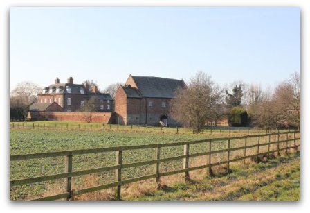
The Manor House and Gatehouse
The Mavesyns moved from their manor house at Blithbury, on the site of the present Blithbury Bank Farm, to Trentside around 1140 when they founded the Church. According to Mark Eades (The Old Hall, A Historical Description and a Guide to the Gatehouse):
‘It is logical to presume that at that time they built a Manor House adjacent to the Church on the site of the present Hall. The nature of the original house is entirely conjectural. It would certainly have consisted of a Hall with outbuildings and was probably enclosed within a moat.
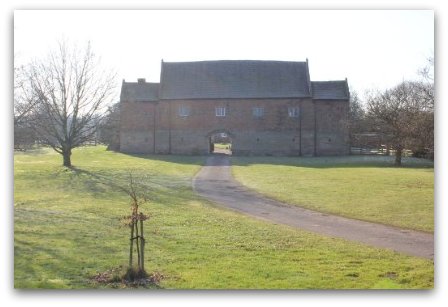
The Manor House appears to have developed into a quadrangular complex. The final building of this evolutionary development was probably the Gatehouse, which completed the quadrangle by enclosing the north side of the courtyard. The Gatehouse is all that remains of the medieval Manor House.
The Gatehouse is a timber framed building of two storeys with a massive Crown Post Roof. The timbers for the frame were felled in late 1391 or before the spring of 1392. In 1995 the Nottingham University tree-ring dating laboratory took eight core samples from various timbers and were able to establish this date accurately. In the Middle Ages oak timbers were worked unseasoned and therefore the building date is 1391 or 1392. The first record of the Gatehouse itself comes in 1407 when Bishop John Brughill granted Dame Johanna Malvesin a license to have masses celebrated in the family oratory, which tradition places in one of the main chambers of the Gatehouse.’
Mavesyn Ridware was designated a conservation area in 1974. The documentation relating to this states that ‘the Gatehouse is one of the architectural show-pieces of Staffordshire’. The neighbouring Old Hall on the site of the Manor House dates from 1718; the attention to detail and the proportions give it a far nobler appearance than the late 18th century description, “a convenient box”, would suggest. Nearby are the fishponds as a further reminder of the Middle Ages.
The Church of St Nicholas
The Church of St Nicholas was founded in 1140 and, as noted in the church guide:
‘the tower and north aisle are thought to date from this period. All except the tower and north aisle were rebuilt to be as it appears today. This rebuilding was undertaken in 1782, because the whole church except the tower and Trinity Aisle being very damp and ruinous was taken down, by a faculty and a new one erected in the same year at a cost of £730’.
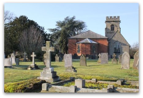
The Trinity Aisle may once have been a family chantry chapel and contains many effigies and tombs of the lords of the manor since the 12th century. Of particular note is the tomb of Hugo Mavesyn, founder of the church and of Blithbury Priory, dated to the late 1100s and forming an integral part of the north wall. The tomb of Sir Henry Mavesyn, the crusader, is also in this aisle.
Sir Robert Mavesyn is buried in a tomb in the Chapel. A translation of the Latin inscription states, ‘Here lies Robert Mavesyn, who was slain at Shrewsbury 1403, standing with the King and fighting by his side even unto death. On whose soul may God have mercy.’
Until the early part of the twentieth century, the church was plastered and whitewashed. For reasons that are not known, the walls were stripped to leave them as they are today. Electricity was brought to the church in 1937.
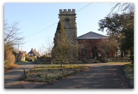
St Nicholas Church, Mavesyn Ridware
The Old Rectory
It is thought that a Rectory was built at about the same time as the church in 1170. Land in Mavesyn Ridware was granted by Hugo Mavesyn senior, to his son Hugo, a clerk, who became the first incumbent. Of the first building nothing remains, apart from two walls in the dining room which are made of large sandstone blocks, similar to those used in the oldest part of the church. A probate inventory of 1672 mentions parlours, a stone chamber and a hall. The Rev John Shaw’s probate inventory of 1710 mentions a much larger building including at least eight rooms, a kitchen, a garret and two cellars (one for beer and one for wine). In 1857 the Bishop commissioned a report on the property, from which the following is extracted:
‘I have made a survey of the Rectory House at Mavesyn Ridware and find it a two storey brick and tile building occupied by a labourer and built in a low damp situation. The rooms are exceedingly low and inconvenient and although in a tolerably good state of repair for so old a house it is wholly unfit for the residence of the Rector; the outbuildings are very poor with the exception of the Glebe barn which has been re-tiled a few years back with good tiles and is in a tolerably good state of repair.
Samuel Guiders, Surveyor. 14th February, 1857’.
This Tithe Barn is shown below. The Old Rectory was leased in 1904 to Miss Harvey of Abbots Bromley who ran a private school in the building with her sister until 1914, when the school closed owing to the death of one of the sisters.
The Battle Beside the Trent
An incident of great interest took place in the parish in 1403. Disputes had arisen over the years between the Mavesyns and the Handsacres, whose lands were divided by the natural boundary of the Trent. The following description of the affray is based on the account given in Dent and Hills, Historic Staffordshire:
‘As early as 1382 Robert Mavesyn had leased to John Hammond, fisherman, his fishery in the Trent at Bryggewater, between Handsacre and the Oxonholme Pool, and the miller, one Robert Mulner, got into dispute as to the boundary of the two parishes at the mill dam and floodgates. The dispute resulted in a feud and an affray, ending in a riot, in which the mill was burnt and Lawrence de Frodesley, of the Handsacre party was killed by the Mavesyns.’
This local disagreement was heightened by the political situation of the time when King Henry IV was defending his crown against Henry Hotspur and his father, Henry Percy, the Earl of Northumberland. Both parties were calling supporters to arms: the King at Burton and Percy at Shrewsbury where he was to join forces with Owen Glendower, the Prince of Wales. Mavesyn supported the King, while Handsacre supported Hotspur.
Such was the state of affairs when Mavesyn and Handsacre assembled their little bands of tenantry , bowmen, billmen and horsemen, according to their degree. The muster was a hasty one. Mavesyn’s object was to reach the King at Burton, or join him on his march; Handsacre’s to meet Percy’s forces coming from the north…the fight took place… The result was that Sir William Handsacre was killed. A few days after this skirmish Sir Robert Mavesyn was killed at the Battle of Shrewsbury.’
|
The next generation however seemed to make their peace as Sir Robert’s daughter Margaret married William, the son and heir of the Handsacre knight. The tomb of Margaret Woodford, the grand-daughter of Sir Robert Mavesyn and Sir William Handsacre is in the Chapel of the church. The fight traditionally took place in a meadow just above High Bridge, in fact the actual spot used to be pointed out, and was hard by two very ancient oak trees, popularly known as Gog and Magog. The sketch shows their massive appearance as late as 1896, but by 1920 they were blackened hulls and they finally disappeared in 1921 when they were broken up and carried away during the long coal strike of that year. In 1995, Tom Adams was metal detecting in soil that had been disturbed when gas pipes were being laid to bring gas into the village. He found two coins, a few inches below the ground, in Church Lane that he took to Birmingham Museum to be dated. One was a silver penny of the Archbishop of York’s mint and is thus dated between 1413 and 1422. The other is a contemporary forgery of a copper halfpenny of George III, dated 1775. |
|
Stebbing Shaw's Account of Mavesyn Ridware Writing in the late 1790s, Shaw states that: ‘the face of the country is pleasingly variegated, rich and well cultivated, exhibiting an agreeable mixture of corn and grass, the fields being well fenced with flourishing thorn-hedges, luxuriant in bloom, and sufficiently thickened with forest trees’. He examined the Church Registers that had to be kept from 1538 and required that all ‘christenings, weddings and buryings’ be registered. From this, he collated the following:
Stebbing Shaw also noted some extracts from the Church Book dated 1643 – 1695. The following indicate how the parish of Mavesyn Ridware was caught up in the Civil War of 1642-6. (The original spellings are kept.)
Shaw also noted the following, which gives an indication of the population of the parish over the years: ‘In 25 Henry VIII. Here were 36 householders belonging to this church’ (This is a regnal year, between 22nd April 1533 and 21st April 1534.)
Mavesyn Ridware Enclosures The next comprehensive survey of the area following Domesday was undertaken in the 1830s when the Inclosures Act was being finalised. John Myatt (Mavesyn Ridware Field Names, 1992) has extrapolated the following information for agriculture in the parish between these two dates. ‘From the Domesday survey (that states four ploughs) and using the customary ratio of one plough per 120 acres we arrive at an arable area of 480 acres under cultivation around 1066. This would have been in the north and south of the parish.’ From this he deduced that about 1,450 acres remained uncultivated and states: ‘Domesday provides clear evidence of the nature of this middle ground: woodland one and a half leagues long and as much broad. The league was a somewhat variable measure, but if we take it to represent a mile, then one and a half leagues square would represent 1,440 acres - the area of the parish not accounted for by the two manors. It follows that, during the seven and a half centuries which elapsed between the Domesday Survey and the survey of 1832, this vast area was reclaimed from woodland for farming use. In 1832 only 43 acres of ‘plantations and coverts’ remained and even these appear to have been recently planted, perhaps to provide alternative hunting and shooting opportunities following the enclosure of Needwood Forest.’ In the same publication the probable location of the medieval open fields evident from Tithe maps of 1844 and 1848 have been identified. ‘Three meadows alongside the River Trent were still partially divided into numbered strips on these maps as were parts of two arable fields south east of Hill Ridware.’ They would have been worked from dwellings within the villages. Some of the older existing cottages may have originally been farmhouses with rights in the open field system. Following enclosure, the old farmhouses would then have been let to farm workers or craftsmen who supplied services to the community. Juxta House in Hill Ridware is a case in point. It is thought to be of 16th century or earlier origin and would have been the home of a moderately affluent yeoman farmer. It was also noted that: ‘There is no record of any Inclosure Award affecting the Parish of Mavesyn Ridware and it is assumed that the enclosures were achieved by voluntary agreement.’
| |||||||||||||||||||||||||||||||||||||||||||||||||||||||||||||||||||||||||||||||||||||||||||||||||||||||||||||||||||||||||||||||||||||||||||||||||||||||||||||||||||||||||||||||||||||||||||